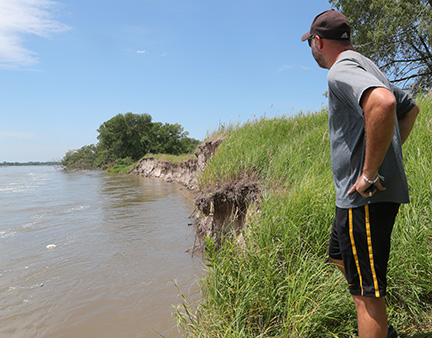
River levee being monitoredby Nathan Arneal With all-too-familiar scenes of flooding coming from Kearney and central Nebraska following heavy rains last week, people down river have been keeping a wary eye on the Platte. That includes North Bend city officials and fire department personnel, who have been inspecting the Platte River levee west of North Bend weekly since the March flood. As the river has risen in the past week, those visits have been increased to twice a day. The most vulnerable spot on the levee is a 50-yard stretch about 1.5 miles west of the Highway 79 bridge, just east of Riverview Shores. Prior to the March flood, there was about 90 yards of dry ground between the river bank and the levee. The flood water erased all that and now the river washes directly against the levee, causing part of it to erode. The flooding also deposited a new sandbar on the south side of the river that rises 2 to 3 feet above the water and helps push the current north against the levee. City councilman Ken Streff has been one of the people keeping a close eye on this section of levee. Last Wednesday, when the river was at its highest and fastest following the Kearney-area rains, he watched three different chunks of the levee separate and fall into the river. Since then, little if any erosion has occurred. On Friday, NBFD personnel put up small yellow marker flags along the edge of the levee. On Saturday, all those flags remained in place, showing that no additional erosion had occurred. Streff said water flowing over the levee is not a concern now, but having the levee fail and collapse is a more likely scenario. Official flood stage is considered 8 feet. On Saturday, the National Weather Service monitoring station on the Highway 79 bridge measured river depth at 5.5 feet. “We’re at 5.51, and they’re projecting another half foot, tops,” Sterff said. “We can handle that. You’re going to see some eroding, but it would take another two to three feet or a faster current to cause a failure.” Just north of the levee are a series of ponds where dirt was taken to build the levee in 1971. Streff said if a heavy rain were to raise the water level in those ponds, the levee could have water working on it from both sides. He called that scenario the biggest threat to the levee. Read the full story in the print or e-edition.
<<Back to the front page |